Showing posts with label Land Survey. Show all posts
Showing posts with label Land Survey. Show all posts
Friday, March 8, 2024
Saturday, May 5, 2018
New "Notes" mode in Planimeter on iOS.


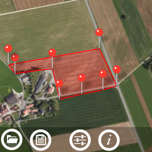
Now with Planimeter on your iPhone or iPad you can label each pin with a message, edit it, save and share via KML or CSV files. KML files with notes, created in the app on one platform (iOS or Android), can be opened and edited on the other one.
With this feature extra information added to your measurements and mapping results should help you with better field planning and records management.
How to drop a pin with a note:
- switch to Notes Mode
- add pins on the map as in Touch Mode
- write a note in the popup dialog
Labels above the pins are visible only when Notes Mode is selected. Simply touch a note over a pin in order to edit or erase text.
Enjoy the app and let us know if you have any feedback!
- add pins on the map as in Touch Mode
- write a note in the popup dialog
Labels above the pins are visible only when Notes Mode is selected. Simply touch a note over a pin in order to edit or erase text.
Enjoy the app and let us know if you have any feedback!
Tuesday, October 31, 2017
Multiple areas measurements on Google Maps with new Planimeter 5.0.
 |
| Multiple areas measurements in Planimeter 5.0 on Android |
A new version of our Planimeter app for measurements on Google Maps has been released and available on Google Play now. We've listened to our customers feedback and the most requested features and tweaks have been added to this version.
What's new:
A new polygon control panel can be called by touching "Add polygon" button from the main screen of the app, where you have access to the new functionality.


From there you can add multiple polygons on the map during measurements session. Total values of area, perimeter and distance are automatically calculated when new points or polygons dropped. For better visualization you can quickly change color of a polygon. Each measured area can be labeled and the title and area value are written over the polygon.
There are also changes to the way the measurement session saved and shared. Now if you use "Save" button your current measurement session with all polygons is saved in KML file. Using standard menu option "File" you can open this file later. Moreover the KML with multiple polygons can be opened in Google Earth and you can see all measured polygons with corresponding labels, distance and area calculations there.


Also when you share your measurements via e-mail, data about each polygons and total area, perimeter and distance calculations will be added to the email body as text.
 Two new functions to work with multiple areas are also added to the drawer menu.
Import allows you to add polygons from previously saved KML files to your current measurement session*. It comes very handy if you want to combine your single-area KMLs, saved in the previous versions of the app, on the one map view and calculate total values.
Export allows you to extract a selected polygon and save it as a new single-area KML file.
Help in the app has been also updated with more details about new features, control tips and shortcuts.

Please try the new version of the app and let us know how it works for you. Your feedback and suggestions are always appreciated and help us to improve the app.
* - currently you can add up to 10 polygons to one measurement session if the "Multiple Areas" feature is purchased.
Friday, July 25, 2014
Planimeter - GPS Area Measure for iOS. How to manage files. Save and Open previously saved measurements.
 This video demonstrates how to manage your measurements using Save and Open features in recently released Planimeter - GPS Area Measure app on iOS.
This functionality is very useful not only for saving your area and distance measurements but also can be very handy for storing your favorite locations to visit later again or to map an initial spot you want come back to (e.g. to find your car, property, house, park, tent, tree, etc.)
Planimeter - GPS Area Measure is our mobile application for different land measurements on maps using Geo-coordinates, Satellite view with manual touch or GPS tracking. The app can be applied in such areas as farming, road building and repairing, construction and planning, solar panel installation, real estate business, hiking and travel and many others.

|
Thursday, July 24, 2014
"Planimeter - GPS Area Measure" - popular Android app for measurements on maps is now available for iOS.

We have had many requests from users about developing iOS version of our popular map measurement app - “Planimeter - GPS area measure”. The app has been available on Android platform for some time and received very positive feedback.
We are proud to announce that the first version of "Planimeter - GPS area measure" has been released and available on the App Store.
This version of the app is not exact copy of the Android tool in terms of functionality. Android version of Planimeter has evolved over time (with kind help, feedback and suggestions from the app users) from a simple tool for manual distance estimation on Google Maps to the tool with many handy features used by professionals on a daily basis. The first iOS version of the app uses Apple Maps and already offers plenty of features for comfortable and productive work:
- Accurate distance and area calculation
- Metric and Imperial units (m, km, feet, yards, miles, ha, acres)
- Angle between lines
- Bearings To and From selected point
- Forth and Back navigation through points by touch on Info Panel
- GPS coordinates of a point
- GPS accuracy settings (if GPS available)
- Manage previously saved projects: open, save, share KML files
- KML files created by Planimeter can be imported to Google Earth and Google Maps to view on a desktop
- Send data by email: picture, coordinates as text message, KML file
- Save KML or TXT in local storage
- Map/Satellite View
- Zoom and Edit points
- Current location search
- Text (address) search
- Delete selected/last/all points
- Zoom to Fit-in and center points on a screen - quick points search
- Add points by touch
- Add current location as a point
- Show location with Latitude and Longitude coordinates
- Add points by Geo-coordinates: Lat and Lng
- Option to center last point added
- Option to show/hide lines
- Preferences: location accuracy, tracking time interval, delete points confirmation, sound option for tracking
- Separate units settings for distance, area, perimeter
- Target Mode for accurate pin placement
- Show current coordinates in Target Mode
- Stylus Draw Mode
- Full-screen option
- GPS TRACKING
- Manual pin placement option in GPS Tracking
You can read our recent post, Measurements on Google Maps using Planimeter App, about Android version that gives a good overview of the app, its applications and user experience with the app. We hope the app will also be useful for iOS users.
Here is an example how you can quickly estimate area on the map in manual mode:
Monday, July 14, 2014
"Planimeter - GPS Area Measure" Update v.3.7.4: KML Export to Google Earth improved with DMS Format fix.

"Planimeter - GPS area measure" app for Android has been updated with a fix for Geo-coordinates format recorded in KML file.
Now when clicking on a pin in Planimeter KML file ( imported into Google Earth or Google Maps), you can see correct DMS coordinates of a point along with related measurement information.
Subscribe to:
Posts (Atom)