SolarMeter - GPS Solar Measure is Android solar energy analyzer tool that allows you to calculate and estimate solar power and energy output of a solar cell panel at specific location. SolarMeter helps you to check solar potential of your roof, how much solar power you are getting at your location throughout the year and to estimate how much energy a photo-voltaic system can generate per month. SolarMeter Features:
Real-time solar power calculation based on current location, panel/device orientation and panel/device tilt
Solar Power and Energy calculation for different period of time: day, month, year
Ideal (calculated) and experimental statistical solar data (offline) available
Sensor based inputs for orientation and tilt
Automatic current location search using GPS and Network
Graph/Plot 2D data presentation
Solar panel efficiency control
Bill and Saving estimation based on user input (energy monthly or annual consumption).
Roof tilt angle measurement
Roof area calculation based on Planimeter* or/and Partometer* apps measurements
Metric and Imperial units
GoGreen! * Note: These apps need to be installed to be able to use them for measurements.
Tracking Mode is one of the distinctive features of Planimeter - GPS Area Measure app. It can be used to measure track or path distances and to measure areas of objects or territories by driving/biking/walking around. You have an option to set GPS accuracy (if GPS is available on your device) and time interval for dropping a pin. If both conditions are satisfied, your current location is added to to the track automatically. Please note, mobile GPS provides accuracy ~2-3m in the best conditions, so make sure it is enough to satisfy your particular requirements.
Sometimes you want to measure an area or distance using tracking feature but you need to place waypoints manually only at certain locations and avoid redundant points in between. You can do it by selecting MANUAL option for the tracking time interval
[LONG TOUCH on Track button ]
to see time interval options for Tracking Mode. “Set Point” button will appear at the bottom of the screen. Now when you start tracking, your current location - green pin- will be constantly updated as long as GPS accuracy condition is satisfied. When you are ready to add a point to your measurement track - just touch “Set Point” button.
Tracking Mode with Manual option is a very handy feature and can be applied for different tasks. For example, it can be used for mapping objects or places for later use or visit.
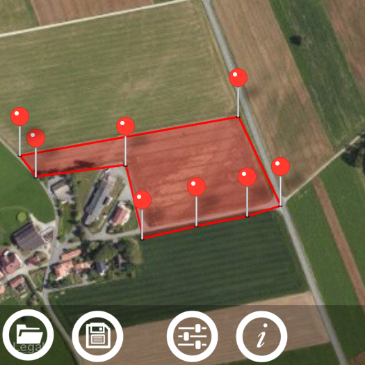
Another application where manual tracking can be useful is marking your property with poles. First you can manually (by touch) build a pole line on maps in Planimeter with required distances between pins. Then you can use Tracking with Manual option enabled to visually estimate your current location (green pin) relative to the planned path and red pins (poles) on it. As soon as you are close enough to the planned point you can place a pole and move to the next point. Planimeter Manual for iOS Described functionality available on both iOS and Android versions of the app.
This video demonstrates how to manage your measurements using Save and Open features in recently released Planimeter - GPS Area Measure app on iOS.
This functionality is very useful not only for saving your area and distance measurements but also can be very handy for storing your favorite locations to visit later again or to map an initial spot you want come back to (e.g. to find your car, property, house, park, tent, tree, etc.)
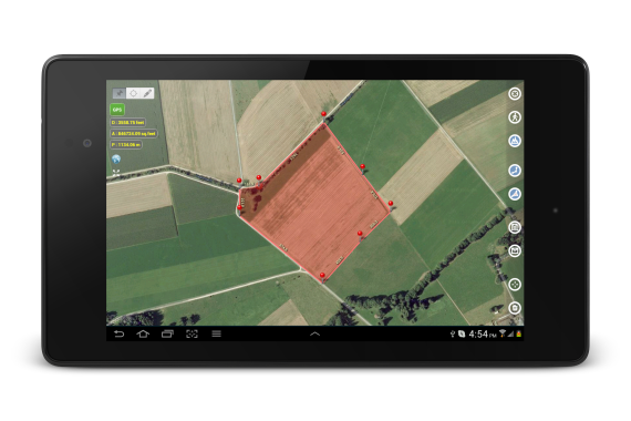
Planimeter - GPS Area Measure is our mobile application for different land measurements on maps using Geo-coordinates, Satellite view with manual touch or GPS tracking. The app can be applied in such areas as farming, road building and repairing, construction and planning, solar panel installation, real estate business, hiking and travel and many others.
We have had many requests from users about developing iOS version of our popular map measurement app - “Planimeter - GPS area measure”. The app has been available on Android platform for some time and received very positive feedback.
This version of the app is not exact copy of the Android tool in terms of functionality. Android version of Planimeter has evolved over time (with kind help, feedback and suggestions from the app users) from a simple tool for manual distance estimation on Google Maps to the tool with many handy features used by professionals on a daily basis. The first iOS version of the app uses Apple Maps and already offers plenty of features for comfortable and productive work:
Accurate distance and area calculation
Metric and Imperial units (m, km, feet, yards, miles, ha, acres)
Angle between lines
Bearings To and From selected point
Forth and Back navigation through points by touch on Info Panel
You can read our recent post, Measurements on Google Maps using Planimeter App, about Android version that gives a good overview of the app, its applications and user experience with the app. We hope the app will also be useful for iOS users.
Here is an example how you can quickly estimate area on the map in manual mode:
We would appreciate any feedback, early bug reports and improvement suggestions from you. Please contact us at support@vistechprojects.com.
In this video we want to show you how o measure radius, length and area of a circle and find its center using the Circle Measurement Mode in Partometer App on iOS. Distinctive feature of the mode that it's possible to measure a partially visible circle.
Partometeris a camera tool for measurements on pictures / photos. The app is available on both platforms iOS and Android.
New update v1.0.3 for the iOS version of Pupil Distance Meter has been released.
We have made some improvements to the measurement process and also included important information on the screen during the measurement procedure. It should help to understand key point for the successful and accurate measurements. The info button at the upper right corner of the screen provides content-dependent info / help. It means the information shown on touch is related to the current measurement step or state of the app. Thus you can see help tips at each step of the measurement procedure.
The basic and main app states are:
- taking two SUCCESSIVE pictures of a face with a reference (e.g. credit card) automatically during one session. 3 sec interval allowed to move the camera from the face to fit a new pattern scale.
- marking pupils and reference bounds with the screen rulers on BOTH (!) images
- rulers alignment confirmation using switch at the right bottom corner (have to be done for BOTH pictures)
ONLY after the rulers are properly aligned and confirmed for BOTH pictures - the actual measurement results are shown at the top of screen.
Although all important key points are mentioned in the video
we still see that some users have difficulties with understanding the measurement procedure and it causes improper results.
The accurate results can be achieved ONLY if you:
- follow the instruction thoroughly (see video)
- make accurate ruler alignment
- DO NOT MOVE OR TILT OR SHIFT YOUR HEAD AND REFERENCE (!) while taking two successive picture. It is VERY important that pictures are taken for the same head and card position (!). ONLY PART YOU CAN MOVE between taking 1st and 2nd pictures is YOUR DEVICE.
We hope this info can help you to understand the measurement procedure better and improve your experience with the Pupil Distance Meter app that is designed to provide accurate PD measurement.
If you have questions or suggestions please contact support@vistechprojects.com, we will be glad to help you.
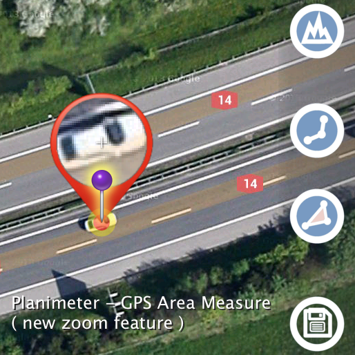
This feature comes in handy when you need to adjust pins accurately on the map while working in Edit Mode. It solves the problem with fingers blocking a view while editing your measurements and also brings some extra zoom for more accurate pin placement.
Magnifying Glass option is available in Preferences and enabled by default in the latest version of the app.
See a short video how the new zoom feature helps to place pins on Google Maps accurately:
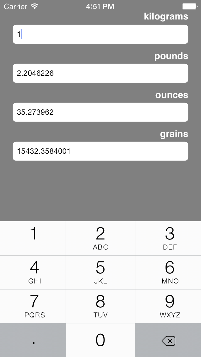
Converter4U - simple, handy and free* units converter for iPod, iPhone and iPad now updated to version 1.1.5.
A value entered in one input field is instantly converted to the other units available on the screen.
4 categories are available in the app: Distance, Area, Mass, Temperature.
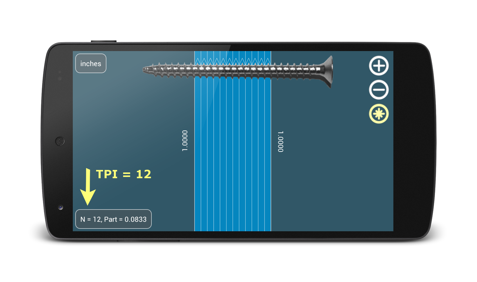
Millimeter Pro for Android and iOS is a small handy ruler on screen of your device. You can measure small objects on the screen: dimensions, area, angle, split linear and circular object in equal pieces. Millimeter Pro can be used as a thread gauge to measure TPI or thread pitch.
"Planimeter - GPS area measure" app for Android has been updated with a fix for Geo-coordinates format recorded in KML file.
Now when clicking on a pin in Planimeter KML file ( imported into Google Earth or Google Maps), you can see correct DMS coordinates of a point along with related measurement information.
Our Pupil Distance Meter (PDM) app is currently available on both platforms Android and iOS. Though these two apps are named the same they use different methods for PD calculation.
We have listened to feedback from Android users and have updated the app webpage with guide and tips how to improve measurements accuracy. The method used in the Android version is sensitive to measurement conditions and requires proper head and reference position and very accurate rulers adjustment. Although the app does image processing and quick automatic measurements, sometimes it is necessary to correct rulers position manually.
However the app users tend to use the PDM without browsing the guide and following important tips. For such app lack of attention to the details usually causes misunderstanding of the measurement procedure and inaccuracy in calculations.
Based on Android experience we have come up with a new idea for the PD measurement and decided to implement it on iOS platform first. The main goal of the iOS version of the app is to test a new approach, to improve accuracy and consistency of measurement results and app usability in general.
First version of the iOS app offers manual measurements and requires two different pictures of a face for accurate PD calculations. Although we have tried to automate the process of taking pictures, pupils and a reference have to beaccurately marked on both pictures manually. Working with two pictures might take more time for a measurement session but it improves accuracy of the results.
Users are still required to follow the instructions and put some effort into learning the measurement procedure, but it is common for such apps and as soon as they are familiar with the app good results can be achieved.
As we expected the new method appears to be quite accurate and not so sensitive to the measurement conditions but still is very sensitive to accurate rulers alignment on both pictures. Simulation and accuracy test results are presented on the app webpage where you can compare it with usual ruler measurements.
Based on our tests Pupil Distance Meter app for iOS returns more accurate and repeatable results compared to other apps on the market for this purpose. It also shows big improvement compared to our Android version of the app.
We plan to update the Android version of the app with the new method currently used in the iOS version. Any feedback or suggestions are welcome.
Areas, distances and angles can be quickly measured on Google Maps using Android phones and tablets with “Planimeter - GPS area measure” App.
Planimeter has a wide range of features that makes it a good choice for amateurs and professionals. The app is used in such areas as farming, road building and coating, construction and planning, solar cell panels installation, real estate, etc.
"This is a must have tool if you have any reason to use geographical area or distance measurements."
"Great! This application is awesome. I use it all the time on the go to calculate acreage and distance for new fields. I would recommend this to any farmer or custom harvester."
Key Features
Units and Formats
Measurement results (distance and area) can be presented in metric or imperial units. Meters, kilometers, feet, yards, miles, hectares and acres are available for distance and area calculations. Geo-coordinates are supported in DD and DMS formats.
Inputs
Polygons and paths can be measured and marked with pins in different ways: manually using touch screen, by entering geo-coordinates or using current location from GPS/Network , using address search.
Tracking
There is an option to make measurements using real-time tracking. The GPS tracking feature makes measurements as simple as walking or driving around an area of interest. Time intervals and accuracy for GPS tracking can be selected in settings or with shortcuts right from the main view.
"...After taking the client to meet a lot of rural areas, the application show the road traveled and the total area of the property. Really very useful and simple to use."
Sharing And Export Results
Measurement results can be shared as a text message, screenshot or KML file through e-mail, messengers, Google Drive or other suitable applications installed on user's device.
KML format allows users to export measured results to Google Earth or Google Maps or any applications with KML support. KML file contains detailed information about each point and measured values, so this information can be viewed in Google Earth or Maps by clicking a corresponding pin/marker8.
File Management and Edit options
Previously saved measurements (KML files) can be previewed, opened and edited through Planimeter app. Along with basic editing options such as Select, Move , Add or Delete a pin or multiple pins, there are some interesting smart path processing functions for quick automatic data editing. These are very useful features if a user has to deal with a large number of data points (e.g. in case of real-time GPS tracking or using drawing mode) or just need to simplify and remove redundant data before saving it into KML file.
Tablet support
The app supports both portrait and landscape modes for large screens what brings even better work experience on tablets. The user is able to select appropriate mode in the settings.
Applications
The availability of useful features combined with “easy to use” experience makes Planimeter app a good choice not only for personal use (e.g. hiking or jog planning) but also for professionals working in such areas as farming, road building, sealing and coating, construction and planning, solar panel installation, real estate business and many others.
Many positive reviews and comments from the app users give a good overview of real life examples where Planimeter can be applied and used on daily basis and how it can simplify users work.
"Great Tool Found this to be the most useful and easy app to use for GPS assisted layouts. I've searched many apps and this one is the only one that simplifies the process and gives you the most information you need for project layouts."
"Great app! Use to get an estimate of different pastures sizes. Worth a lot more to me."
"This app covers all my needs regarding area measuring. It turns into the perfect tool for tracking field work."
"I use this app to measure areas for paving. Has worked well so far. The trace feature is excellent for measuring chopped up and irregular areas."
"Great app. Works great and it's easy to read the data into Google earth"
"This is still the best app available until Google Earth Pro is allowed to work on Android devices."
WHRMeter is an Android app that calculates Waist To Height Ratio (WHR) and health risk based on it, Body Mass Index (BMI) and estimates Cardiovascular Disease Risk (CVD).
Using Body Mass Index you can check your optimal weight for given height.
Key Features:
optimized for tablets
imperial and metric units
convert input values to different metric system
instant WHR, BMI calculation and CVD estimation
show current weight condition (underweight, overweight, obesity level) and calculate optimal weight range
presenting results in different forms
show your results relative to a full scale of values for better understanding
share your parameters (age, height, weight, etc.) and calculation results
help section
no permissions and pop-up ads
Check HELP in the app for more info about WHR, BMI and CVD The app is FREE and does not contain any permissions or pop-up ads.